Researchers have unveiled Itiner-e, the most detailed open digital dataset of Roman roads ever assembled, covering nearly 4 million km² and nearly doubling previously known road lengths. The dataset reveals only 2.737% of road locations are known with certainty, highlighting significant archaeological unknowns while enabling transformative studies of ancient mobility, trade, and infrastructure evolution. This resource integrates historical sources, modern topography, and remote sensing with segm
Unearthing the Digital Backbone of an Empire: The Itiner-e Dataset
The Roman Empire's road system stands as one of antiquity's most remarkable engineering achievements, enabling military dominance, economic integration, and cultural exchange across continents. Yet, despite centuries of study, a comprehensive, precisely geolocated digital map of this network remained elusive – until now. Itiner-e emerges as a monumental leap forward, offering the most detailed and extensive open dataset of Roman roads ever compiled, fundamentally reshaping our understanding of ancient terrestrial mobility.
Beyond the Barrington Atlas: Scale and Methodology
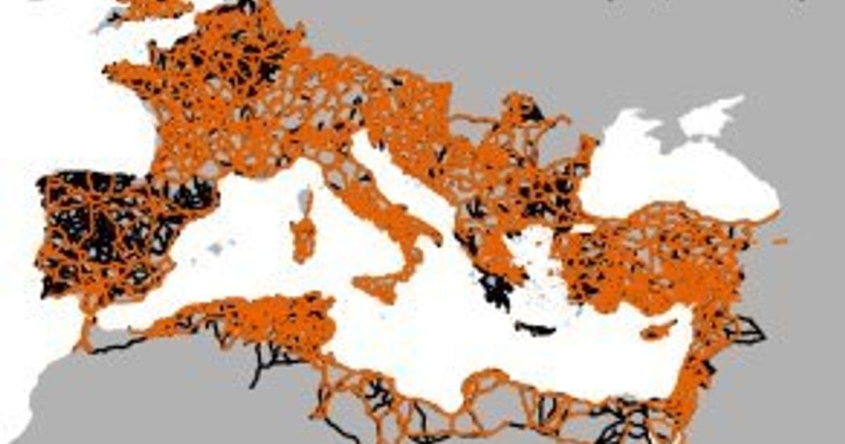
The new dataset, published on Zenodo (https://doi.org/10.5281/zenodo.17122148) and accessible via the Itiner-e platform, catalogs a staggering 299,171 km of roads across the Roman Empire at its peak (c. 150 CE). This represents nearly double the length captured in previous resources like the Barrington Atlas-derived Digital Atlas of Roman and Medieval Civilizations (DARMC, 188,555 km). This dramatic increase stems from:
- Expanded Coverage: Filling critical gaps in understudied regions like the Iberian Peninsula, Greece, Egypt, and North Africa (Figs. 1b, 2a).
- Enhanced Spatial Resolution: Digitizing roads with far greater detail (5-200m target resolution), adapting routes to actual geographical features like mountain passes rather than simple straight lines, resulting in more vertices and realistic lengths (Figs. 1c, 2b).
"The dataset includes 14,769 road segments and consists of 14 connected components, reflecting the contiguous landmasses... The core of the Roman terrestrial transport network were those roads classified as main roads... covered 103,477.9 km (34.58%)... The dataset further includes 195,693.3 km (65.42%) of secondary roads."
The creation of Itiner-e was a massive collaborative effort spanning 2020-2024, led by projects like MINERVA and Viator-e, involving meticulous cross-referencing and digitization:
flowchart LR
    A[Identify Roads] --> B[Locate Roads]
    B --> C[Digitize & Attribute]
    A --> Sources["Archaeological reports, historical itineraries
 (Antonine Itinerary, Tabula Peutingeriana),
 milestones, gazetteers (Pleiades, Vici.org)"]
    B --> Data["Modern/historical topographic maps,
 aerial photos, satellite imagery
 (including Corona, SRTM DEM)"]
    C --> GIS["GIS digitization with segment-level metadata
 (Type, Certainty, Chronology, Bibliography)"]
Figure 3: Simplified workflow for the Itiner-e data creation process.
The Stark Reality of Uncertainty: Certainty Categories and Confidence Mapping
A groundbreaking revelation from Itiner-e is the quantification of locational uncertainty:
- Only 2.737% of the total road length is classified as Certain (high spatial accuracy).
- 89.818% is Conjectured (lower accuracy based on evidence and topography).
- 7.445% is Hypothetical (minimal evidence, often in deserts/floodplains).
This starkly illustrates the gap between knowing a road existed and precisely pinpointing its path. To address this, the team developed innovative confidence maps (Figs. 5, 6). These combine:
- Representativity: Assessing coverage (road density per 0.5°x0.5° cell) and resolution (vertices per km).
- Reliability: Judging source quality (High/Medium/Low based on regional scholarship depth).
The resulting confidence scores highlight areas needing future research focus (e.g., Northern England, Upper Danube, Central Anatolia) and provide crucial context for interpreting spatial analysis results derived from the dataset. The maps reveal that 39.51% of the analyzed area falls into the lowest confidence categories.
Technical Validation and Open Platform for Growth
Recognizing inherent biases from preservation, research focus, and landscape changes, the team emphasizes transparency. The confidence maps explicitly visualize data heterogeneity. Itiner-e isn't static; the associated platform allows the scholarly community to:
- Contribute new road data as discoveries are made.
- Suggest corrections or alternative interpretations of existing segments.
- Utilize tools like routing for ancient journeys and 3D landscape visualization.
"Itiner-e makes such gaps in our current knowledge of Roman roads explicit for the first time, allowing this information to inform robustness tests and uncertainty quantifications of future studies, and specifying how and where future data collection efforts can improve our knowledge."
Implications: Rewriting the Map of Antiquity
Itiner-e is transformative for diverse fields:
- Ancient History & Archaeology: Enables precise modeling of travel times, trade route efficiency, military logistics, administrative control, and disease spread dynamics.
- Long-Term Landscape Studies: Provides a baseline for analyzing millennia of infrastructure evolution and human-environment interaction in Europe, North Africa, and the Near East.
- Digital Humanities & Geospatial Analysis: Offers a massive, structured dataset with rich metadata for network analysis, least-cost path modeling validation, and integration with other ancient world datasets.
- Cultural Heritage: Aids in identifying, preserving, and interpreting surviving road remnants.
The dataset, available in Shapefile, GeoPackage, and GeoJSON formats, comes with comprehensive field descriptions and a linked Zotero bibliography. By nearly doubling known road lengths while quantifying profound locational uncertainty, Itiner-e doesn't just map the past; it charts a clear course for the future of large-scale archaeological infrastructure research, revealing how much we still have to discover about the pathways that shaped the ancient world.
Comments
Please log in or register to join the discussion