Google Earth's often-overlooked historical imagery feature allows users to explore satellite and aerial views dating back to the 1930s, revealing dramatic transformations in landscapes, cities, and neighborhoods. This guide unpacks how to access and navigate this tool, examining its technical underpinnings and implications for geospatial data enthusiasts. For developers and historians, it offers a rare window into the power of digital archiving and its role in preserving our collective past.
The recent viral surge in nostalgic Google Street View explorations has captivated users rediscovering personal histories through decades-old imagery. Yet, few realize that Google Earth harbors an even more powerful temporal tool—a hidden slider enabling journeys up to 80 years into the past. Unlike Street View’s ground-level snapshots, this feature layers satellite and aerial data into an interactive 3D timeline, transforming how we witness urban metamorphosis, climate impacts, and architectural evolution. For developers and technologists, it’s not just a trip down memory lane; it’s a masterclass in geospatial data aggregation and visualization.
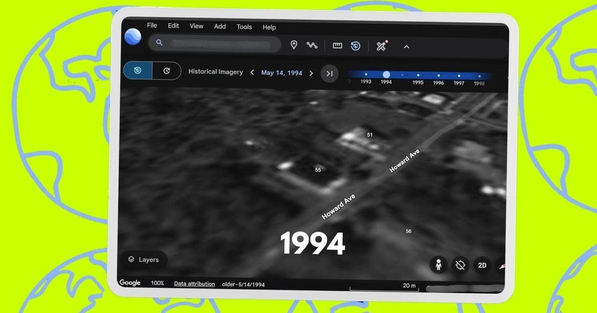
Tapping into the Timeline: A Technical Walkthrough
Accessing historical imagery requires enabling a specialized layer—a process streamlined across web and mobile platforms but rich with nuances. On desktop, navigate to Google Earth’s Satellite view via the Layers panel, then activate the Historical Imagery toggle from the toolbar or under View > Historical Imagery. Mobile users tap the layers icon (☰), select Historical Imagery, and hit Apply. This summons a timeline slider, where large dots denote annual snapshots and smaller ones indicate monthly updates. Urban centers like London or Berlin often boast dense data trails back to the 1940s, while rural areas may have sparse coverage. As Elyse Betters Picaro notes in her ZDNET report:
"In Malone, NY... I saw timeline dots for every year in the present-day, a few dots in the early 2000s, one in the 1990s, and a final one in 1985. In Syracuse, NY... dozens more dots appeared."
Resolution varies starkly across eras: pre-1990s imagery typically appears as grainy, 2D aerial mosaics, while modern views leverage high-definition 3D satellite renders. Toggling between dimensions is intuitive—look for the 2D/3D button—but older data often forces a flat perspective to optimize performance. This isn’t a flaw; it’s a deliberate engineering trade-off prioritizing accessibility over fidelity.
Behind the Scenes: Data Sourcing and Technical Nuances
The magic hinges on Google’s vast partnerships with imagery providers like The GeoInformation Group, stitching together aerial photos and satellite feeds into a cohesive timeline. As Picaro explains, ground-level views derive from single images, while aerial perspectives are mosaics—complex composites that can warp at zoom levels. Developers should note the Data Attribution link in the corner, revealing sources and capture dates, which underscores the collaborative effort behind this digital archive. Recent updates, including the September 2024 rollout of deeper historical access, highlight Google’s commitment to enriching this repository, though gaps persist in less-documented regions.
Why This Matters Beyond Nostalgia
For tech professionals, this tool exemplifies how geospatial data can drive innovation in urban planning, environmental monitoring, and AI training. Imagine feeding historical imagery into machine learning models to predict urbanization patterns or assess disaster recovery. Yet it also raises questions: How do we sustainably archive petabytes of visual data? What ethics govern the digitization of private spaces over decades? As we manipulate the slider, we’re not just observers—we’re participants in a living archive, one that challenges us to build more resilient, transparent tools for future generations. The true power lies not in rewinding time, but in harnessing its lessons to code a better tomorrow.
Comments
Please log in or register to join the discussion