
A new open-source tool called Sightline allows users to search and analyze real-world infrastructure like telecom towers, power plants, and data centers using OpenStreetMap data. Built with Node.js and Next.js, it provides a natural language interface for geospatial intelligence, raising questions about the accessibility of infrastructure mapping data.
The open-source intelligence (OSINT) community has a new tool for mapping the physical world. Sightline, a geospatial intelligence platform, enables searching and analyzing real-world infrastructure using data from OpenStreetMap (OSM). The project, developed by ni5arga, is designed for discovering assets like telecommunications towers, power plants, data centers, airports, and military installations.
How It Works
Sightline operates on a simple premise: it translates natural language queries into structured searches against OSM's vast dataset. The tool connects three key services:
- Nominatim: Converts place names into geographic coordinates and bounding boxes. For example, a query for "telecom towers in karnataka" gets geocoded into a specific region.
- Overpass API: Executes the actual queries against OSM's read-only data layer. This API is the workhorse, fetching the infrastructure points based on the parsed parameters.
- Frontend Interface: A Next.js application provides the search bar, filters, and a Leaflet-based map view to visualize results.
The project's architecture is straightforward. The app/api/search/route.ts file handles the backend logic, parsing queries and making requests to the external APIs. The lib/parser.ts file contains the natural language processing logic, while lib/overpass.ts constructs the Overpass QL queries. Caching is handled in-memory via lib/cache.ts to reduce redundant API calls.
Querying Infrastructure
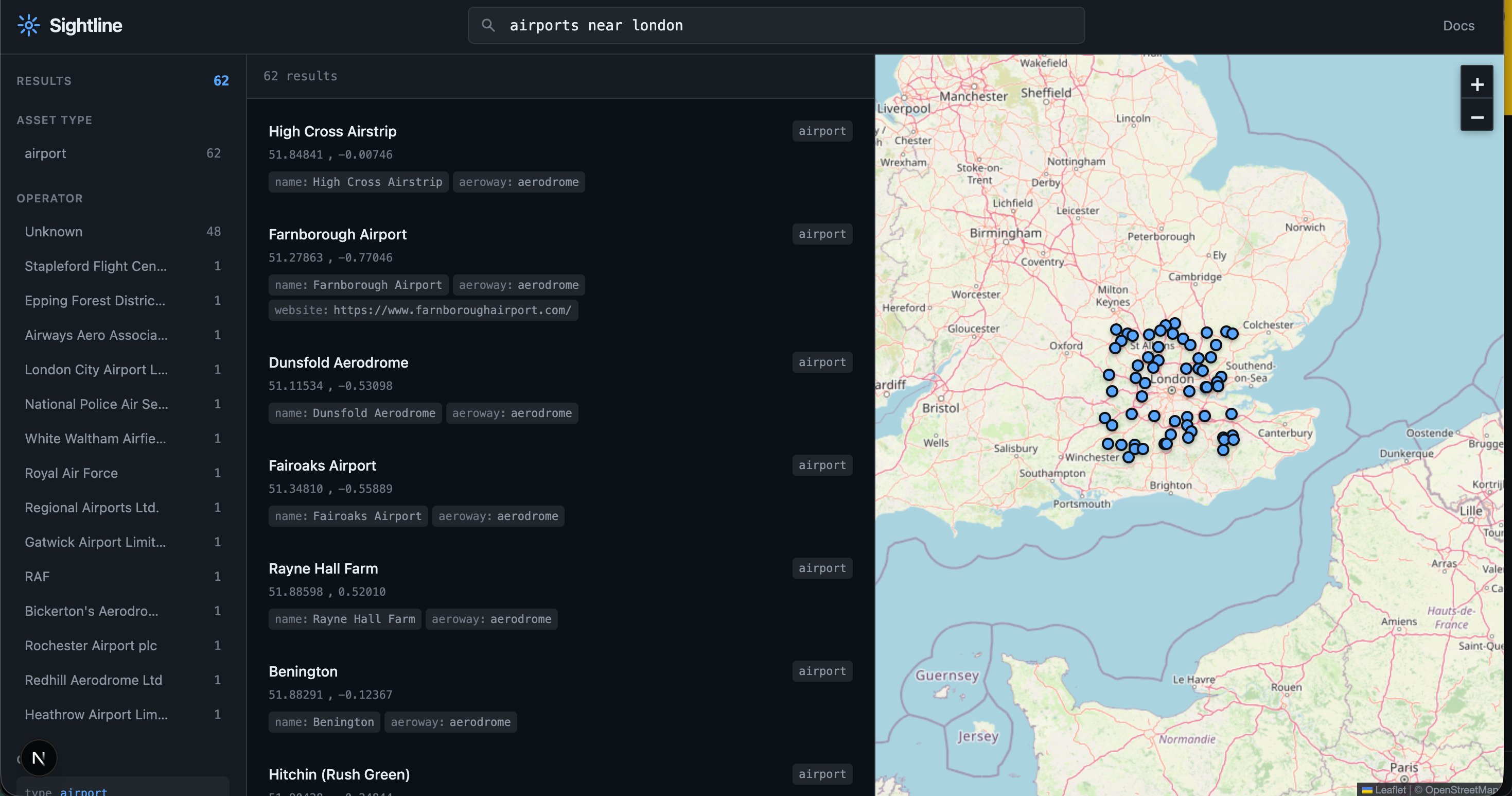
Sightline supports both natural language and structured queries. A user can type "power plants near mumbai" or use a more precise syntax like type:power_plant operator:google region:texas. The system supports a wide range of asset types, categorized into sectors like telecommunications, energy, transportation, and government/military.
For instance, a search for type:telecom operator:airtel region:karnataka would query OSM for all telecommunications infrastructure (towers, antennas) tagged with the operator "Airtel" within the Indian state of Karnataka. The tool also supports proximity searches using parameters like near:london and radius:100 (for 100 km).
Development and Deployment
The project is built with modern web technologies. It requires Node.js 18+ and uses npm for package management. Setting it up locally involves a standard npm install and npm run dev command, with the application running on localhost:3000.
Deployment is straightforward, with Vercel being the recommended platform. Notably, the application requires no environment variables, as it relies entirely on public OpenStreetMap APIs. This makes deployment simple but also places the responsibility of respecting API rate limits on the user.
Data Sources and Limitations
The core data source is OpenStreetMap, a collaborative, crowd-sourced mapping project. This is both a strength and a limitation. While OSM contains a wealth of information, it is not an official, authoritative source. The data can be incomplete, outdated, or inaccurate. The project's documentation explicitly states: "The presence or absence of infrastructure in OSM should not be taken as authoritative. Always verify critical information through official sources."
The tool also relies on Nominatim and the Overpass API, which have their own usage policies. Nominatim enforces a rate limit of 1 request per second, and the Overpass API operates under a fair use policy. The project includes a responsible use section, warning against illegal surveillance, harmful purposes, and bulk automated queries that could overload public infrastructure.
Responsible Use and Ethical Considerations
Sightline is a powerful tool for geospatial analysis, but its capabilities come with ethical responsibilities. The ability to map infrastructure like military bases, power plants, and data centers raises privacy and security concerns. The project's license (MIT) and its clear guidelines for responsible use aim to mitigate these risks, but the ultimate responsibility lies with the user. The tool is a reminder that a significant amount of infrastructure data is publicly accessible through OSM, and this data can be queried and visualized with relatively simple software.
Conclusion
Sightline represents a practical application of open data and modern web development. It lowers the barrier to entry for geospatial intelligence, allowing anyone with a query to explore the physical infrastructure of the world. While the data is not official and must be used responsibly, the project highlights the potential of tools that can synthesize and present public information in an accessible way. For developers, researchers, and analysts interested in infrastructure mapping, it offers a ready-to-use framework that can be extended or customized for specific needs.
Comments
Please log in or register to join the discussion