The quirky 50-year 'Whisky War' over barren Hans Island ended not with bullets, but with satellite imagery and precision mapping. This technical deep dive explores how modern geospatial technology and geological surveys enabled Canada and Denmark to peacefully split the Arctic outcrop, setting a precedent for resolving resource-rich territorial disputes.
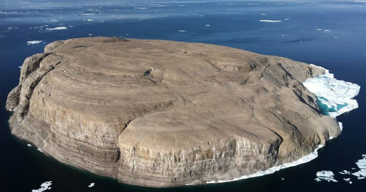
For nearly five decades, a windswept, uninhabited rock in the high Arctic sparked one of history's most peculiar border disputes. Hans Island (Tartupaluk), a mere 1.3 square kilometers of Silurian limestone rising from the frigid waters of the Kennedy Channel between Ellesmere Island and Greenland, became the unlikely focal point of the "Whisky War" between Canada and Denmark. Its resolution in 2022 stands as a testament not to military might, but to the power of precise geospatial technology and geological understanding.
The Geological Chessboard
The island itself is a geological artifact. As detailed in Canadian Geological Survey Open File 5321, Hans Island consists of nearly 200 meters of Silurian limestone, predominantly composed of fossilized megalodont bivalves, stromatoporoids, and corals. Field investigations and stereoscopic air photo analysis revealed distinct layers:
- A 60m thick upper layer of yellowish-brown to grey limestone
- A 10-12m thick pale yellowish-brown marker bed
- A 125m thick, cliff-forming coral and bivalve limestone layer
Crucially, seismic surveys indicated these strata sit atop over 3,300 meters of Lower Cambrian to middle Silurian sedimentary rock. While potentially hydrocarbon-bearing source rocks lie below, the lack of trapping structures dashed early resource speculation. The surface, sculpted by glacial ice streaming through the channel, is covered in unconsolidated till and marked by glacial striations, flutes, and ridges – features meticulously mapped via aerial photography and satellite imagery, providing critical context for the eventual border delineation.
The Tech That Drew the Line
The dispute's origin was analog: ambiguous nautical charts and the 1973 continental shelf treaty that deliberately omitted drawing a line between points 122 and 123 – the gap where Hans Island sat. For years, the conflict manifested in symbolic gestures: Danish flags and bottles of schnapps versus Canadian flags and bottles of Canadian Club.
The turning point came with advanced satellite imagery and remote sensing. By 2007, updated satellite data revealed a harsh reality for both nations: a geodesic line calculated as the simplest maritime boundary would have split the island roughly down the middle. This wasn't a political proposal initially, but a technical revelation derived from precise orbital positioning and image analysis. It forced a fundamental shift in negotiations away from outright ownership claims towards practical division.
The Joint Task Force on Boundary Issues, established in 2018, leveraged this data alongside:
- High-resolution topographic mapping: Accurately depicting the island's terrain, highest point (168m), and natural features.
- Geological fault line identification: Recognizing a natural rift running north-south near the island's center as the optimal, defensible dividing line.
- Precision coordinate calculation: Defining the new border using three exact land points (T1, T2, T3) and 149 maritime points, all specified by latitude and longitude down to tenths of seconds.
{{IMAGE:5}} The new border established by the 2022 treaty, dividing Hans Island roughly 60% (Greenland/Denmark) to 40% (Canada), following a natural geological rift. (Credit: Derived from Treaty Coordinates)
Beyond the Map: Implications for Arctic Tech and Policy
The resolution, formalized on June 14, 2022, created the world's northernmost international land border – a 1,280-meter line traversing the island. Beyond ending a quirky dispute, it sets significant precedents:
- Validation of Geospatial Tech: Demonstrates how satellite imagery, GPS, and digital mapping can provide irrefutable baselines for resolving complex territorial disagreements where traditional surveying is impractical.
- Model for Arctic Cooperation: Provides a blueprint for peacefully settling other Arctic sovereignty and resource disputes (e.g., Beaufort Sea, Lomonosov Ridge) using technical evidence and joint task forces.
- Resource Clarity: While immediate hydrocarbon potential on Hans Island is low, the precise delimitation removes ambiguity for future seabed mineral exploration and research in the surrounding Nares Strait, governed by the 1983 marine environment cooperation agreement.
- Digital Diplomacy Quirk: The brief 2005 "Google Fight," where ads staked rival claims, highlighted how even digital platforms can play a role (however informal) in modern territorial narratives.
The Hans Island settlement proves that in the 21st century, the most potent tools for resolving border conflicts aren't battleships, but orbiting satellites, geological surveys, and the algorithms that turn their data into indisputable lines on a map – served with a side of shared schnapps and whisky, of course.
Source Attribution: Content synthesized from the Wikipedia entry on Hans Island (en.wikipedia.org/wiki/Hans_Island), incorporating details from geological surveys (Harrison et al., 2007), treaty texts (1973 Continental Shelf Agreement, 1983 Marine Environment Agreement, 2022 Border Treaty), and historical accounts of the dispute resolution process.
Comments
Please log in or register to join the discussion