ESA's Meteosat Third Generation-Sounder satellite has returned its first images, showcasing revolutionary hyperspectral capabilities that will transform weather forecasting across Europe and northern Africa.
The European Space Agency has unveiled the first images from its revolutionary Meteosat Third Generation-Sounder (MTG-S) satellite, marking a significant milestone in weather forecasting capabilities for Europe and northern Africa. The satellite, positioned approximately 36,000 km above Earth's surface in geostationary orbit, began transmitting data on November 15, 2025, revealing unprecedented detail about atmospheric conditions.
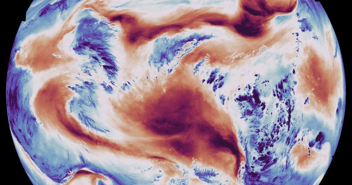
The initial images demonstrate the satellite's remarkable capabilities through two distinct channels. The temperature image, captured using the Infrared Sounder's long-wave infrared channel, reveals Earth's surface temperature alongside cloud-top temperatures. In this visualization, dark red areas indicate high temperatures primarily found on land surfaces, while blue regions represent cooler temperatures typically associated with cloud tops. The image clearly shows the warm landmasses of Africa and South America, with the Cape Verde peninsula near Senegal's capital Dakar appearing among the warmest areas. The western coasts of Namibia and South Africa are visible beneath swirling cold cloud formations, while Brazil's northeast coast appears in dark red.
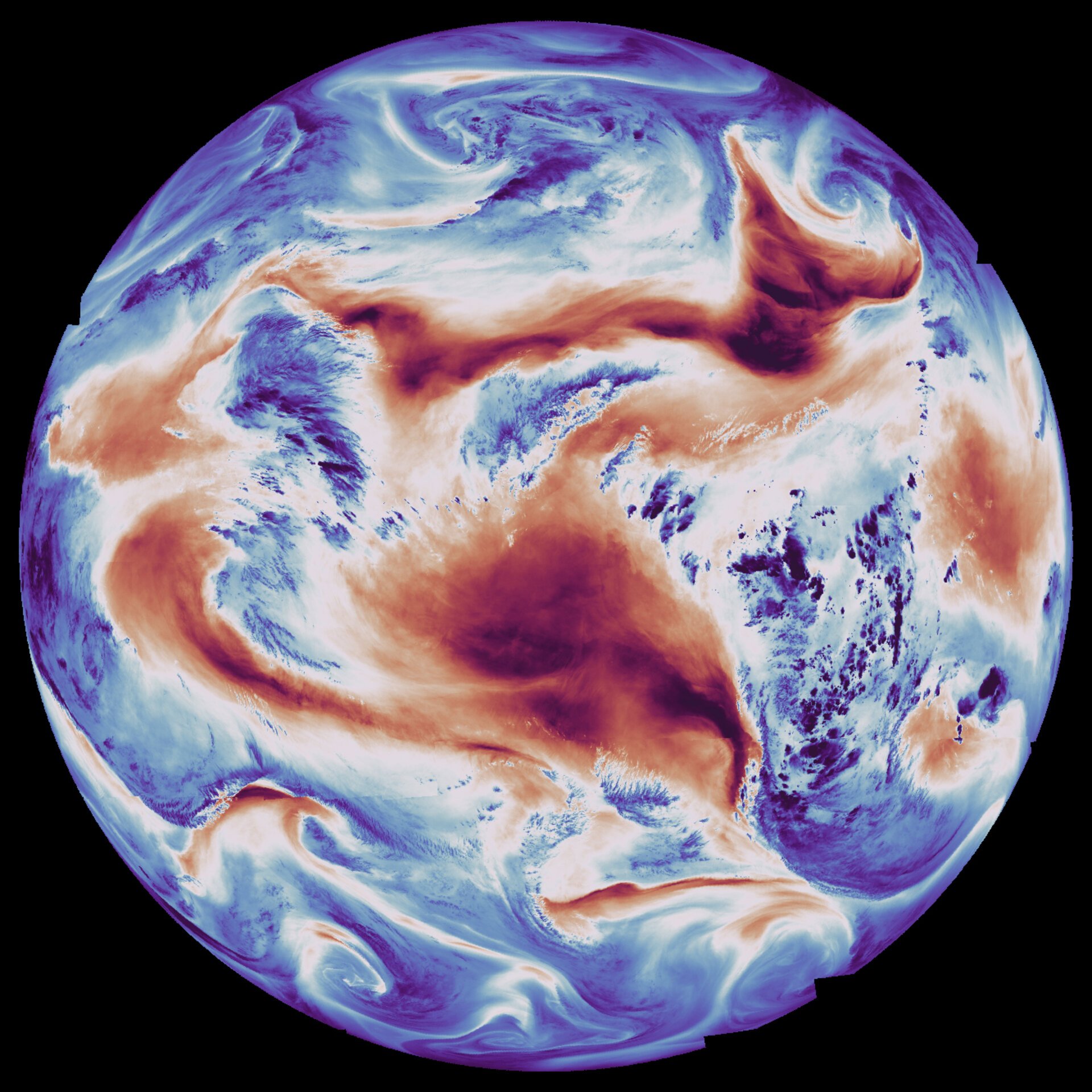
Complementing this, the humidity image utilizes the medium-wave infrared channel to measure atmospheric moisture levels. This visualization presents a dramatically different perspective, with blue colors indicating regions of higher humidity and red colors showing lower humidity. Notably, the outlines of landmasses are not visible in this image, emphasizing the instrument's focus on atmospheric conditions rather than surface features. The Sahara Desert and Middle East appear as areas of minimal atmospheric humidity, while patches of high humidity are visible over eastern Africa and in both high and low latitudes.
A close-up view of Europe and northern Africa further demonstrates the instrument's capabilities, showing heat signatures from land surfaces alongside temperature variations at cloud tops. The image reveals a dark blue weather front covering Spain and Portugal, with the Italian peninsula prominently centered in the frame.
Perhaps most dramatically, the satellite captured the eruption of Ethiopia's Hayli Gubbi volcano on November 23, 2025. The animation combines surface temperature data with infrared channels to track the developing ash plume, demonstrating the satellite's ability to monitor rapidly evolving atmospheric phenomena in real-time.
This technological leap represents the culmination of 15 years of development and collaboration between ESA, Eumetsat, the European Commission, and numerous European industry partners. The MTG-S satellite's geostationary position allows it to maintain a fixed observation point relative to Earth's rotation, providing comprehensive coverage of Europe and northern Africa on a 15-minute repeat cycle.
The mission's significance extends far beyond traditional weather monitoring. The Infrared Sounder instrument represents Europe's first hyperspectral sounding capability in geostationary orbit, utilizing interferometric techniques to analyze minute patterns in light waves. This sophisticated approach enables the satellite to capture data on temperature, humidity, wind patterns, and trace gases in the atmosphere.
What makes this mission truly revolutionary is its ability to generate three-dimensional atmospheric maps. By combining data from all 1,700 infrared channels continuously acquired by the instrument, meteorologists will soon be able to create detailed vertical profiles of atmospheric conditions. This capability is expected to dramatically improve the accuracy of weather forecasting, particularly for nowcasting rapidly evolving storms.
ESA Director of Earth Observation Programmes, Simonetta Cheli, emphasized the mission's transformative potential: "Seeing the first Infrared Sounder images from the MTG-Sounder satellite really brings this mission and its potential to life. We expect data from this mission to change the way we forecast severe storms over Europe – and this is very exciting for communities and citizens, as well as for meteorologists and climatologists."
The satellite also hosts the Copernicus Sentinel-4 mission, which includes an ultraviolet, visible, and near-infrared imaging spectrometer. This additional capability further enhances the satellite's ability to monitor atmospheric composition and air quality.
With the MTG-S satellite now operational and the second Imager scheduled for launch later in 2026, Europe is poised to lead the world in next-generation weather forecasting. The mission promises not only more accurate weather predictions but also earlier warnings of severe weather events, potentially saving lives and protecting property across the continent.
The successful deployment and initial operation of MTG-S represents a significant achievement in international cooperation and technological innovation. As climate change continues to increase the frequency and severity of extreme weather events, this advanced monitoring capability becomes increasingly crucial for protecting communities and supporting economic activities across Europe and northern Africa.
Comments
Please log in or register to join the discussion