Virginia Tech climatologist Andrew Ellis explains why an atypical La Niña, combined with rising temperatures, has pushed over 60 % of the United States into drought, outlines the regions most at risk, and assesses the prospects for relief later this year.
 )
)
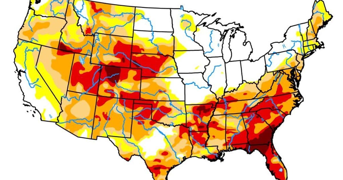
More than 60 % of the United States is currently under drought conditions, with more than one‑fifth in an extreme state. In a recent interview, Andrew Ellis, a climatologist at Virginia Tech, placed the situation in a historical context, highlighted the regions where water stress is most acute, and offered a realistic outlook for the coming months.
The climate driver: an atypical La Niña
Ellis points to the La Niña that dominated the fall and winter of 2025‑26 as the primary catalyst. La Niña describes a cooling of the western equatorial Pacific, which usually nudges the North American storm track farther north along the U.S.–Canadian border. The result is a dry spell for the southern tier of the country.
What makes this episode stand out, Ellis says, is the simultaneous dryness across the Pacific Northwest—a region that typically receives enough precipitation even during La Niña years. “With La Niña in place, the fall‑winter storm track moves north, leaving the southern U.S. without the storm dynamics that generate precipitation,” he explained. The Southwest sees fewer Pacific storms, and the Gulf‑of‑Mexico moisture pipeline that feeds the Southeast is largely shut.
Climate warming amplifies the squeeze
While precipitation deficits trigger drought, Ellis stresses that rising air temperatures increase evapotranspiration, pulling more water from soils and vegetation. In practical terms, the same rainfall deficit feels harsher because the land loses water faster.
Who is feeling the heat?
 United States drought map released by the U.S. Drought Monitor on May 7, 2026. The map focuses on broad‑scale conditions; local variations may differ.
Ellis identifies two hotspots:
- Colorado and the high Rockies – Snowpack is thin, and the region depends on winter storms to refill reservoirs.
- The Southeast, especially Georgia and Florida – Extreme drought stretches from the deep South up through the Mid‑Atlantic, threatening municipal water supplies, agriculture, and ecosystems.
He adds that the central Great Plains and high Rocky Mountains also show deep, widespread dryness, while the Ohio Valley has so far escaped the worst of the La Niña pattern, benefiting from more frequent Gulf‑derived moisture.
States most vulnerable to the current dry spell include New Jersey, Pennsylvania, Kentucky, Tennessee, Arkansas, and Oklahoma. These areas historically rely on late‑fall and early‑winter rain from the Gulf and Atlantic; that “door has been mostly shut for the past six to eight months,” Ellis notes.
Outlook for relief – why summer won’t solve it
Ellis is cautious about expecting a quick turnaround. Summer thunderstorms can bring short bursts of rain, but they rarely replenish depleted soils or restore snowpack. In the Rockies and Great Plains, the bulk of water storage is locked in winter snow; without a solid snow season, summer rains are a band‑aid at best.
The Southeast and Mid‑Atlantic sometimes enjoy wetter summers driven by Gulf and Atlantic moisture, yet these events are often too brief to erase a deep drought. “The most significant relief often comes from late summer or early fall tropical systems, though they carry risks of damaging winds and flash flooding,” Ellis warns.
Looking ahead, the climatologist flags a potentially historic El Niño expected to develop in the fall and winter of 2026‑27. If it materializes, the opposite storm‑track pattern could bring more precipitation to the southern U.S., but the timing and magnitude remain uncertain.
About the expert
Andrew Ellis is a professor in the Department of Geography at Virginia Tech’s College of Natural Resources and Environment. His research spans climate science, snowfall variability, drought monitoring, and freshwater sustainability in arid and semi‑arid regions.
For interview requests, contact Virginia Tech Media Relations at [email protected].
Comments
Please log in or register to join the discussion