QuakeInfo is a long-standing earthquake monitoring app that has recently been updated with a Liquid Glass design and new features, providing real-time seismic data from global databases.
Welcome to Indie App Spotlight. This is a weekly 9to5Mac series where we showcase the latest apps in the indie app world. If you're a developer and would like your app featured, get in contact.
If you live in an earthquake-prone climate, you might be interested in a tool to help monitor them. QuakeInfo is a long-standing app on the App Store, and it's recently been updated with a Liquid Glass design and new features.
Top features
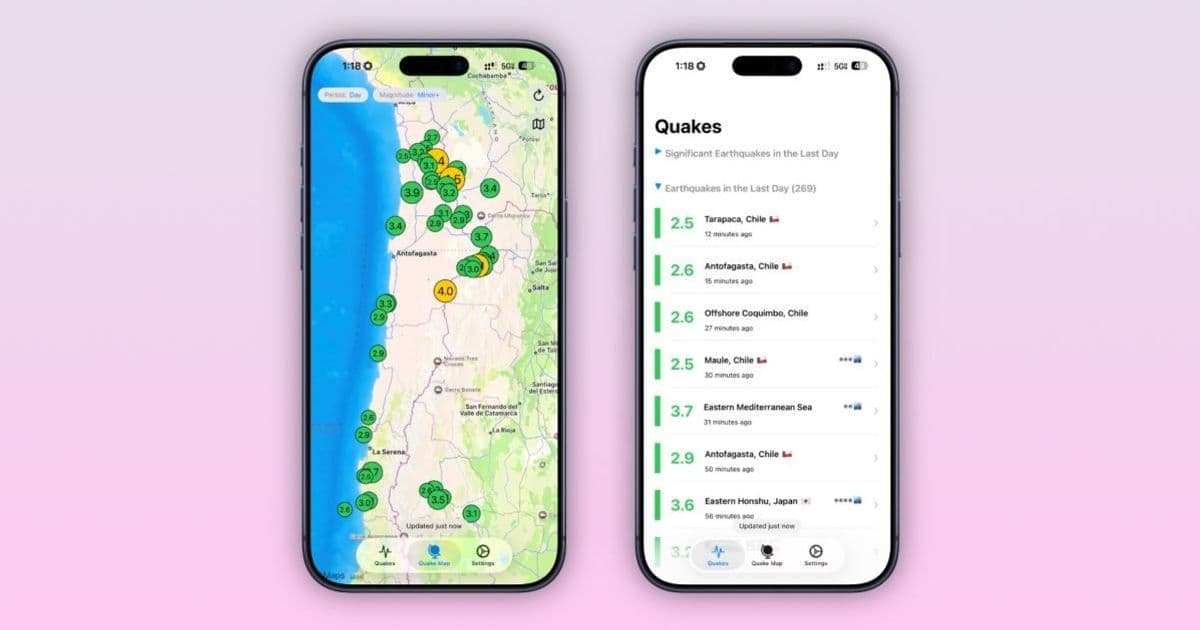
Using data from both US and European databases, QuakeInfo can show you seismic activity from around the world. It puts the map view up front, making everything clear and easy to see. It also has a comprehensive list view, giving you info on each individual earthquake, down to the timing, magnitude, location, and depth.
You can see how far you are from the epicenter, and a clear indicator of how far the earthquake is from populated areas. The app also offers Tsunami warnings. QuakeInfo provides location-based safety warnings, spatial context, and detailed metadata on each individual earthquake – so you know what's coming before it potentially hits you.
For data nerds, you can also scroll through up to a year of historical data on previous earthquakes – which can be useful for making quick comparisons to ongoing earthquakes. Datapoints like magnitude, depth, and so on are available for learning your typical seismic patterns.
QuakeInfo is available for free on the App Store for iPhone users running iOS 18.6 and later. For the full experience, you can purchase QuakeInfo Premium for $1.99/month or $9.99/year.
Why earthquake monitoring apps matter
Living in earthquake-prone regions requires constant vigilance and access to reliable information. Traditional news sources can be slow to report seismic events, and official government websites often have outdated interfaces that make real-time monitoring difficult.
Mobile apps like QuakeInfo fill this critical gap by providing immediate access to seismic data from multiple global sources. The app aggregates information from both US Geological Survey (USGS) and European-Mediterranean Seismological Centre (EMSC) databases, ensuring comprehensive coverage regardless of where earthquakes occur.
The importance of having this information at your fingertips cannot be overstated. During seismic events, every second counts. Knowing the magnitude, depth, and distance of an earthquake helps you make informed decisions about whether to evacuate, seek shelter, or simply stay informed about potential aftershocks.
Liquid Glass design and user experience
The recent update to QuakeInfo brings Apple's latest design language to the app. The Liquid Glass interface provides a modern, translucent aesthetic that feels native to iOS 18 while maintaining excellent readability and usability.
The map-centric approach makes intuitive sense for earthquake monitoring. Users can quickly scan global activity, zoom into specific regions, and tap on individual events for detailed information. The color-coding system helps users immediately identify the severity of different earthquakes without reading through numbers.
Premium features worth considering
While the free version of QuakeInfo provides substantial functionality, the premium subscription unlocks several valuable features:
Historical data access: The ability to view up to a year of historical earthquake data is particularly useful for researchers, journalists, and anyone interested in seismic patterns. This feature allows users to track seasonal variations, identify fault line activity, and understand regional seismic behavior.
Advanced filtering: Premium users can filter earthquakes by magnitude, depth, and time range, making it easier to focus on events that matter most to them.
Custom alerts: Set up notifications for earthquakes above specific magnitude thresholds in your area or regions you care about.
Ad-free experience: Remove advertisements for uninterrupted monitoring.
Technical requirements and availability
QuakeInfo requires iOS 18.6 or later, ensuring compatibility with the latest iPhone models and features. The app is optimized for both iPhone and iPad, though the interface is particularly well-suited to iPhone's form factor for quick, on-the-go monitoring.
The app's size is relatively modest, making it suitable for users with limited storage space. Regular updates ensure that the earthquake databases remain current and that the app takes advantage of the latest iOS capabilities.
Competition in the earthquake monitoring space
While QuakeInfo is a strong contender in the earthquake monitoring category, it faces competition from other apps like Earthquake Network, MyShake, and official government apps. What sets QuakeInfo apart is its combination of comprehensive data sources, user-friendly interface, and regular updates.
The app's focus on both global and local information makes it versatile for different use cases. Whether you're a casual user wanting to stay informed about seismic activity in your area or a professional needing detailed historical data, QuakeInfo offers a compelling solution.
Final thoughts
For anyone living in or traveling to earthquake-prone regions, having a reliable monitoring app is essential. QuakeInfo's combination of real-time data, historical information, and user-friendly design makes it a valuable tool for staying safe and informed.
The recent Liquid Glass update demonstrates the developer's commitment to keeping the app current with the latest iOS design trends while maintaining its core functionality. At $1.99 per month or $9.99 per year for premium features, the pricing is reasonable for the value provided.
Whether you're a resident of California, Japan, or any other seismically active region, QuakeInfo deserves a place on your iPhone. The peace of mind that comes from having immediate access to earthquake information is well worth the download.
Comments
Please log in or register to join the discussion