A comprehensive analysis reveals that over 99% of coastal hazard assessments incorrectly handle sea-level and elevation data, leading to significant underestimations of coastal flood risks. The study shows that measured coastal sea levels are on average 0.27 meters higher than commonly assumed, potentially exposing 48-68% more people to flooding than previously estimated.
A groundbreaking study published in Nature has exposed a critical flaw in the vast majority of coastal hazard assessments worldwide, revealing that sea levels along coastlines are significantly higher than previously assumed in most impact studies. This systematic error has led to widespread underestimations of coastal flood risks and the populations vulnerable to sea-level rise.
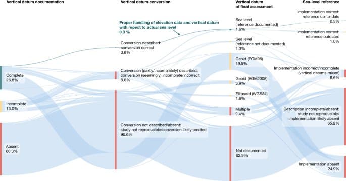
The Scope of the Problem
The research team, led by Katharina Seeger and Philip Minderhoud, conducted an exhaustive evaluation of 385 peer-reviewed scientific publications on sea-level rise and coastal flooding published between 2009 and 2025. Their findings are alarming: more than 99% of these studies handled sea-level and land elevation data inadequately, fundamentally misjudging sea level relative to coastal elevation.
The Core Issue: Geoid vs. Actual Sea Level
The primary problem stems from a widespread assumption in coastal hazard assessments. Most studies assume that coastal sea levels equal global geoid models rather than using actual sea-level measurements. A geoid is an equipotential surface model that approximates mean sea level based on Earth's gravity and rotation, but it doesn't account for ocean currents, temperature, salinity, or other dynamic factors that affect actual sea-surface height.
"The vast majority of the evaluated literature assumed the geoid surface (0 m) to represent contemporary local mean sea level, thereby introducing the above discrepancy as error into their respective coastal hazard and sea-level rise impact assessments," the researchers explain.
The Magnitude of the Error
Through comprehensive meta-analyses, the researchers quantified the magnitude of this misrepresentation. Their findings show that measured coastal sea levels are, on average, 0.27 meters higher than assumed in most hazard assessments, with a standard deviation of 0.76 meters. For the more recent EGM2008 geoid model, the average discrepancy is 0.24 meters with a standard deviation of 0.52 meters.
However, these global averages mask much larger regional discrepancies. In data-sparse regions, particularly in the Global South, measured mean sea levels can be more than 1 meter above global geoids. The Indo-Pacific region shows the largest differences, with some areas experiencing discrepancies of up to several meters.
Implications for Coastal Populations
The consequences of these errors are profound. When the researchers recalculated coastal exposure using properly referenced sea-level data, they found that estimates of people living below sea level after a hypothetical 1-meter rise in relative sea level increased dramatically. Instead of the previously estimated 34-49 million people, the corrected figures suggest 77-132 million people would be affected – a 48-68% increase.
Similarly, the area of land below sea level would increase from 294,500-431,100 square kilometers to 460,100-670,000 square kilometers, representing a 31-37% increase.
Regional Hotspots
Southeast Asia emerges as particularly vulnerable, with the largest population exposure increases. In this region alone, the estimated number of people below sea level following a 1-meter rise could increase by 94-96%, from previous estimates to 24-47 million people.
Other affected regions include Latin America, the west coast of North America, the Caribbean, Africa, the Middle East, and other parts of the Indo-Pacific.
The Vietnamese Mekong Delta Case Study
To illustrate the real-world implications, the researchers conducted a detailed analysis of the Vietnamese Mekong Delta, one of the largest and most vulnerable river deltas in the world. Their findings show that not including proper sea-level referencing added 10-60% additional error to relative elevation assessments, on top of existing data inaccuracies.
Proper inclusion of mean dynamic topography data increased the area and population in the Mekong Delta exposed to a 1-meter rise from 1,400-6,000 square kilometers and 313,000-2.4 million people to 18,400-24,800 square kilometers and 5.4-10.0 million people.
IPCC Assessment Implications
The researchers also evaluated how these errors might have affected major climate assessments. They found that 46 of the evaluated studies were included in the most recent IPCC AR6 reports, with the majority appearing in chapters from Working Group II.
Their analysis suggests that datum conversion errors and sea-level reference omissions may have led to underestimated coastal exposure in IPCC reports. For instance, the reported estimates of people residing in the Low Elevation Coastal Zone (LECZ) were below their estimates following proper mean dynamic topography referencing.
A Community-Wide Blind Spot
The study reveals what the researchers call a "community-wide blind spot" in coastal hazard assessment methodology. This systematic error has persisted despite the availability of better data and more sophisticated modeling approaches.
One contributing factor may be the current constellation that leaves complex geodetic transformations required for correct coastal hazard assessments in the hands of non-specialist end users unfamiliar with the required processing steps.
Recommendations for Improvement
To address these critical issues, the researchers offer several concrete recommendations:
Data Documentation Guidelines: Journals should introduce dedicated steps in their submission and peer-review procedures, including elevation and datum documentation guidelines.
Author Declarations: Researchers should provide declarations about their data handling and conversion methods.
Review Checklists: Adoption of review checklists to aid referees in identifying vertical datum issues.
Data Provider Solutions: Data providers could offer readily combined products of digital terrain with sea level to facilitate proper end use.
Dynamic Elevation Approach: Adoption of a proper "dynamic elevation" approach combining multiple elevation datasets and performing multi-source uncertainty and accuracy evaluations.
The Path Forward
The researchers emphasize that this study likely reveals only the "tip of the iceberg," as the evaluated publications form only a representative selection of the full body of coastal hazard assessments. They express concern that much grey literature, such as policy-forming documents and governmental reports, especially in the more data-sparse Global South, may contain similar issues.
"Our findings may have far-reaching implications for existing coastal adaptation, protection and mitigation strategies, especially those using satellite-derived elevation data as information base," the researchers warn. "This necessitates re-evaluating existing coastal hazard assessments to rule out vertical reference and sea-level datum issues and, if those assessments informed decision-making, potentially updating and expediting implementation timelines of coastal adaptation strategies, as exposure thresholds may be reached much sooner than previously projected."
Technical Solutions
The study also provides practical solutions, including the conversion of several state-of-the-art global digital elevation models to coastal sea-level height and making them ready for use. The researchers have made their processed data and code available to facilitate proper future assessments.
Global North-South Disparities
The research highlights significant disparities in data quality and methodology between the Global North and South. While geoid models perform relatively well in data-rich regions like the United States and Western Europe, they substantially underrepresent actual sea-surface height in data-sparse regions of the Global South.
This disparity may explain the overconfidence placed in geoid-model performance by Global-North-based scientists when performing assessments on a global scale or in other regions where geoid models perform less well.
Conclusion
This comprehensive study exposes a fundamental flaw in coastal hazard assessment methodology that has led to systematic underestimation of coastal flood risks worldwide. The findings call for immediate action to re-evaluate existing assessments and implement improved methodologies that properly account for the difference between geoid-based assumptions and actual measured sea levels.
The implications extend far beyond academic circles, potentially affecting coastal adaptation strategies, climate finance decisions, and policy-making at all levels of government. As sea levels continue to rise and coastal populations grow, the accuracy of these assessments becomes increasingly critical for protecting vulnerable communities and planning effective adaptation measures.
The research serves as a wake-up call to the scientific community, policymakers, and coastal planners worldwide, highlighting the urgent need for methodological improvements and the re-evaluation of existing coastal hazard assessments to ensure they accurately reflect the true risks facing coastal populations.
Comments
Please log in or register to join the discussion