Strava is making route planning more practical for hikers, runners, and cyclists, with clearer maps coming later this summer and new subscriber tools already live.

Strava is rolling out a set of navigation-focused updates aimed at making its mobile app more useful before, during, and after outdoor activities. The headline additions are improved map styles, route saving from more places in the app, off-route alerts, and animated Activity Replays for hikes.
The update matters because Strava has gradually become more than a workout log. For many runners, cyclists, hikers, and trail users, it now sits somewhere between a fitness tracker, route planner, social feed, and lightweight navigation app. These new features push it further into that role, especially for subscribers who already use Strava to plan routes rather than simply record activities after the fact.
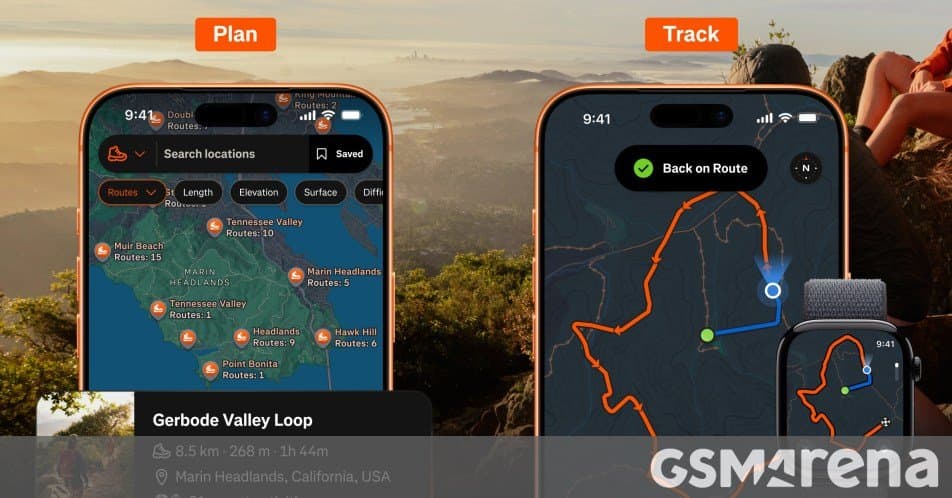
The map style changes are scheduled to arrive later this summer. Strava says the updated maps will include richer trail surface data and clearer points of interest, including trailheads, picnic areas, and campgrounds. That sounds modest on paper, but map readability is one of those details that can change how useful an app feels on a phone screen in direct sunlight, on a trail, or while moving quickly on a bike.
For outdoor routing, surface data is especially practical. A route that looks fine as a line on a map can feel very different if it includes loose gravel, paved road, singletrack, fire road, or uneven trail. Better surface information can help users choose routes that match their gear and comfort level. A road cyclist may want to avoid rough trail segments, while a trail runner may actively prefer softer surfaces and more remote paths. Hikers may care less about speed and more about whether the path connects to a campground, picnic area, or trailhead with parking.
The clearer points of interest also make Strava more competitive with dedicated mapping tools. Apps like Google Maps are strong for city navigation and business listings, while services such as AllTrails and Komoot have built their reputations around outdoor route context. Strava’s advantage is that it already has a huge activity graph from real athletes. If its maps become easier to read and more informative, the app can better connect its social fitness data with actual route decisions.
For subscribers, Route Saves are now available. This lets users save routes from several parts of the app, including the Activity Detail page, Route Detail page, Route Builder, and Edit Route. That matters because route discovery often starts in different places. You might see a friend’s ride, inspect the route, tweak it, then want to save your own version. Or you might build a route from scratch and come back to it later. By adding more save points, Strava reduces the friction between finding a good route and actually using it.
The practical benefit is simple: fewer dead ends inside the app. If you spot a route while scrolling your feed, you should not have to remember where it was, rebuild it manually, or take screenshots. Saving from the Activity Detail page makes borrowed inspiration more useful, especially in areas where local athletes have already found the best climbs, trail connectors, or low-traffic roads.
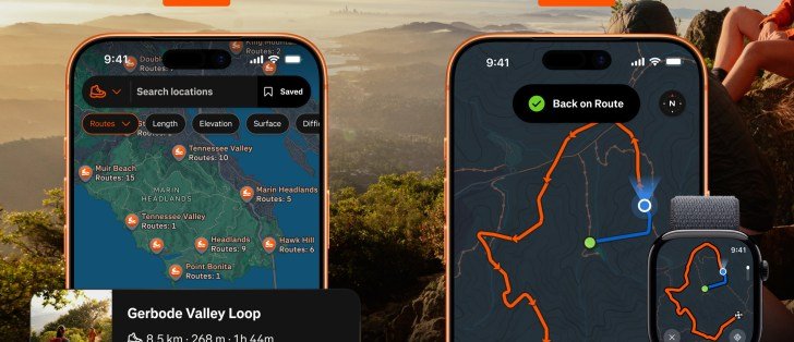
Off-route alerts are another subscriber feature, and they are the most navigation-oriented part of this release. When users stray from a planned route, Strava can now alert them. For cyclists, that can help avoid missed turns on unfamiliar roads. For runners and hikers, it can prevent small mistakes from turning into long detours, especially where trails fork frequently or where signage is limited.
This feature also shows the trade-off in Strava’s current direction. The more Strava behaves like a navigation app, the more users will expect reliability from it. Off-route alerts need timely GPS updates, clear route matching, and sensible battery behavior. Phones already juggle GPS, screen brightness, mobile data, Bluetooth accessories, and background app restrictions. On both iOS and Android, navigation features can be affected by location permissions, battery optimization settings, and whether the app is allowed to run actively during a workout.
That is especially relevant for Android users, since some phone makers apply aggressive background process management. If Strava is expected to warn you when you leave a route, users may need to make sure location access is set correctly and battery restrictions are not interfering. On iPhone, the experience is usually more predictable, but GPS-heavy use can still drain battery quickly on longer hikes or rides.
Activity Replays are also now available for hikes. These automatically animate a hike in the feed, replaying the route from start to finish for friends. This is more of a social feature than a navigation feature, but it fits Strava’s broader identity. The app has always mixed performance data with storytelling. A static map shows where someone went, while an animated replay makes the activity easier to understand at a glance, especially for longer or more scenic routes.
The subscriber-only split is also significant. Strava has been steadily placing its more advanced planning and analysis tools behind its paid subscription, which is detailed on the company’s subscription page. That creates a clear divide between basic activity recording and the more complete route-planning experience. Free users can still use Strava as a fitness log and social network, but the strongest navigation improvements increasingly sit inside the paid tier.
That raises the usual ecosystem lock-in question. Once an athlete saves routes, follows friends, compares segment efforts, builds a history of activities, and depends on Strava’s heatmap-style community intelligence, switching apps becomes harder. It is not lock-in in the same sense as a phone platform or smartwatch ecosystem, but it is still meaningful. Your training history, favorite routes, social graph, and local segment knowledge all live inside the service.
For users with Garmin, Apple Watch, Wear OS, Wahoo, Hammerhead, or other devices, Strava’s value often comes from being the shared layer above the hardware. You might record on a Garmin bike computer, sync from an Apple Watch, or upload from a third-party training app, then use Strava as the place where everything is organized and shared. Better maps and saved routes make that central role stronger.
The downside is that serious route planning often benefits from export options, offline access, and device compatibility. A cyclist may want to send a route to a head unit. A hiker may want offline maps where cellular service is weak. A runner may want turn guidance on a watch instead of constantly checking a phone. Strava has integrations across the fitness device world, but users should still check how these new route tools fit their own setup before treating the app as their only navigation system.
The timing also makes sense. Outdoor fitness apps are competing on context now, not just tracking. Pace, distance, elevation, and heart rate are table stakes. The better question is whether an app can help you choose a smarter route, avoid bad terrain, stay oriented, and share the activity in a way that feels useful afterward. Strava’s latest update targets exactly that middle layer between raw GPS recording and full outdoor navigation.
For casual users, the improved maps may be the most visible change once they arrive later this summer. For subscribers, Route Saves and off-route alerts are the more meaningful additions right now. They make Strava feel less like a place where activities end and more like a tool that helps plan and guide the next one.
Strava has not turned into a full replacement for every dedicated mapping app, and many hikers or cyclists will still want specialized tools for remote routes, offline maps, or advanced trip planning. But this update makes Strava more practical for everyday route discovery and execution, especially for people already living inside its fitness ecosystem.
Comments
Please log in or register to join the discussion