Gated communities account for up to 30% of rides in some Lyft markets, and they break the usual assumption that the nearest geographic point is a valid pickup spot. Lyft's Mapping team turned that mess into a reusable pattern: detect the constraint, encode it in the map, and surface it through pickup selection, routing, and the app layer.
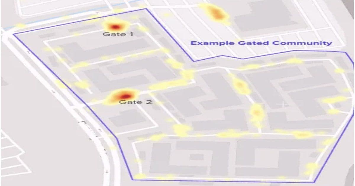
Lyft has published details of a new pickup experience aimed at one of ride-hailing's most stubborn coordination problems: getting a driver and rider to meet when the rider is inside a gated community. According to the company, these pickups make up between 25% and 30% of rides in some markets, which makes the failure mode far more than an edge case. When a driver gets routed to a resident-only entrance, lacks a gate code, or stops at the nearest point on a public road that happens to be on the wrong side of a fence, the result is longer waits, a flurry of calls and texts, and a higher cancellation rate.

What makes this interesting from an architecture standpoint is not the user-facing feature itself. It is the recognition that a navigation system built for public road networks carries an assumption that simply does not hold here. The default mental model of routing, snap the destination to the nearest drivable point and go, is wrong the moment a physical barrier sits between that point and the actual person waiting. Lyft's solution is essentially to teach the map about constraints that road-network data never captured.
What Lyft built
The Mapping team broke the system into four components, and they map cleanly onto stages of the pickup lifecycle.
The first component is detection. Lyft identifies gated communities and generates boundary representations using OpenStreetMap data combined with driver feedback signals. This is the foundational step: before you can route around a constraint, you have to know it exists and where its edges are. The boundaries become first-class geospatial objects the rest of the system can reason about.
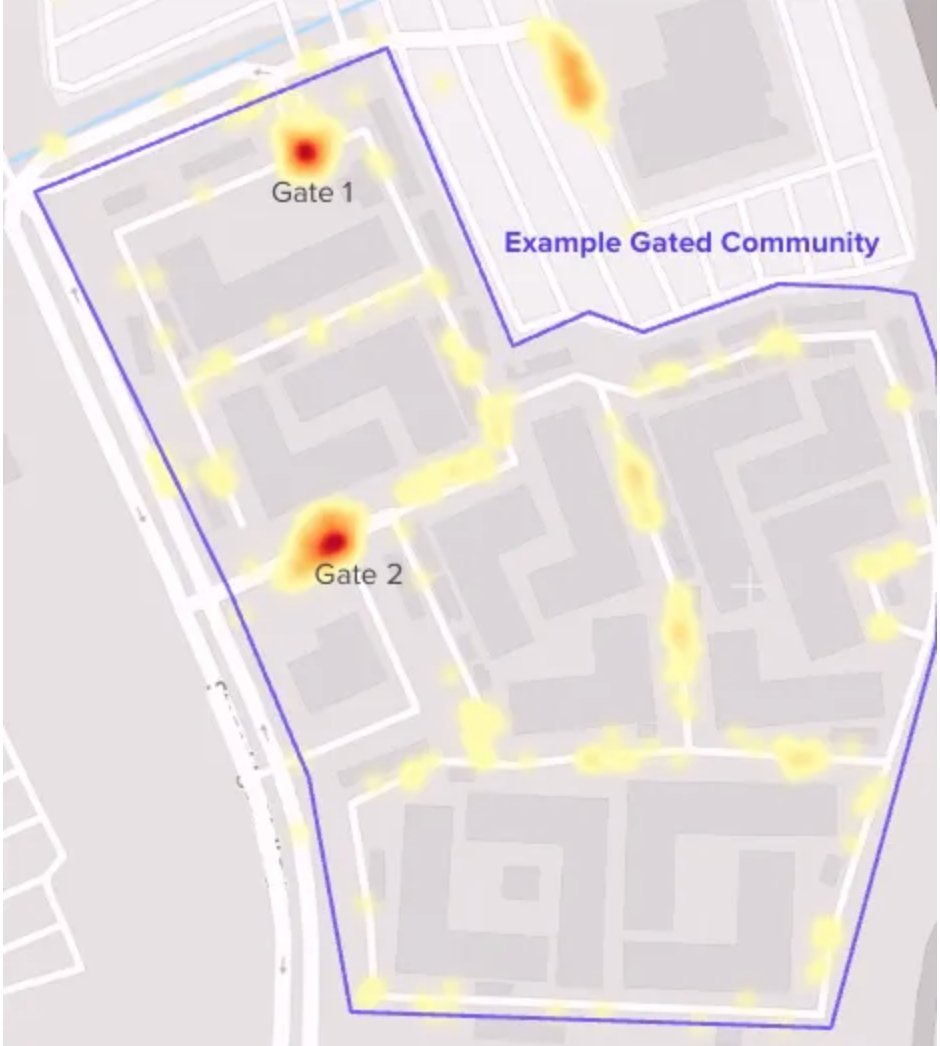
The second component improves pickup recommendations. Instead of dropping a single pin, Lyft offers riders options both inside and outside the gated area. That choice matters, because the optimal meeting point depends on context the platform cannot fully know. A rider with a gate code might prefer an interior pickup, while a rider near the entrance might save everyone time by walking out.
The third component is routing logic. Rather than guiding a driver to the nearest geographic point, the system steers them toward valid entrances. This is the part that most directly fixes the resident-only-entrance problem. The shortest path by distance is frequently the wrong path by access.
The fourth component closes the information gap. Riders can proactively share gate access details, which removes the ad-hoc back-and-forth that otherwise happens in real time while a driver idles at a barrier.
Why proprietary mapping signals matter here
A notable thread running through Lyft's writeup is its continued investment in proprietary mapping capabilities layered on top of open data. The system uses historical pickup and routing patterns alongside driver feedback to improve location accuracy and flag problematic points such as gated communities and apartment complexes. Those signals feed back into routing decisions and meeting-point selection, so accuracy improves as more rides flow through a given location.
This is a feedback-driven design rather than a static dataset. The map is not a fixed artifact you load once; it is a model that gets refined by the operational reality of millions of completed and failed pickups. Achal Prabhakar, a Product and Technology Executive at Lyft, framed the philosophy plainly:
Most good mapping work is invisible by design. People do not open the app to admire our geofences or routing logic. They open it to get to a hospital, a flight, a kid's recital, a friend's house.
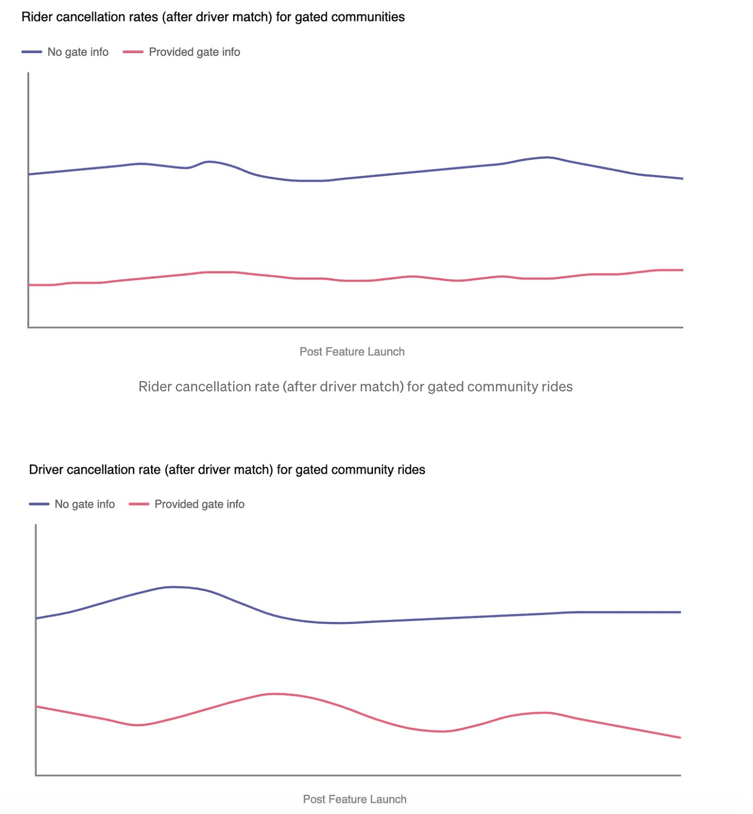
The reported outcome is reduced pickup friction in gated communities, with drivers reaching riders more reliably and less manual coordination required.
The trade-offs worth naming
Nothing about this approach is free. Building and maintaining boundary representations for gated communities is an ongoing data-quality commitment. Communities change, entrances close, access rules shift, and a stale geofence can be worse than none at all because it routes drivers confidently to the wrong place. The reliance on driver feedback also introduces a cold-start problem: a newly built community with no ride history has no signal to learn from, so detection quality is uneven across locations.
There is also a privacy and trust dimension to riders sharing gate access details. That information is sensitive, and storing or transmitting it carries obligations the platform has to handle carefully. The benefit to coordination is clear, but it expands the surface area of data the system holds.
A reusable pattern for real-world constraints
The broader lesson generalizes well beyond gates. Traditional navigation focuses on public road networks, while ride-hailing platforms must account for private roads, restricted entrances, building access, event venues, airports, and temporary disruptions like road closures or unsafe segments. Any of these can invalidate the naive assumption that the nearest point is a reachable point.
Lyft describes the solution as a reusable architectural pattern, and the shape of it is genuinely portable: encode the real-world constraint into the map, surface it during selection, incorporate it into routing, and deliver context-aware guidance in the application layer. That sequence, model the constraint once and let every downstream stage consume it, applies to logistics, delivery, field services, and any system where the digital map and the physical world disagree.
The takeaway for architects is that a seemingly small user-experience complaint, drivers cannot find me, can demand serious investment in geospatial modeling, feedback loops, and routing infrastructure. The friction was small per ride. Multiplied across a quarter to a third of trips in some markets, it justified building the constraint directly into the map.
Comments
Please log in or register to join the discussion